


GTMC2_J2

PhilippeC54
User
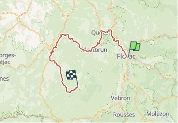

Length
48 km

Max alt
1063 m

Uphill gradient
1438 m
Km-Effort
66 km

Min alt
472 m

Downhill gradient
1031 m
Boucle
No
Creation date :
2016-06-14 00:00:00.0
Updated on :
2016-06-14 00:00:00.0
4h14
Difficulty : Difficult

FREE GPS app for hiking
 SityTrail
IGN / Geographical institutes
SityTrail Plus
The world is yours!
About
Trail Mountain bike of 48 km to be discovered at Occitania, Lozère, Florac Trois Rivières. This trail is proposed by PhilippeC54.
Description
Florac
Nivoliers
Positioning
Country:
France
Region :
Occitania
Department/Province :
Lozère
Municipality :
Florac Trois Rivières
Location:
Florac
Start:(Dec)
Start:(UTM)
547730 ; 4907681 (31T) N.
Comments